Pages

Trek to Kohoj fort (कोहोज चा किल्ला)

Height: ~3200 ft.
Per head cost: 101 ₹ (Dadar to Dadar, including lunch, breakfast, snacks)
21st June, 2014

The per head 101 ₹ included train from Dadar-Palghar-Dadar, one healthy lunch, transport from Palghar-Kohoj-Palghar, snacks- cakes, puran-poli, tea and vada-pav. We were group of 6, which means total amount was 606 ₹. Its funny the groups charge 700-800 ₹ for a single trek - single person!!

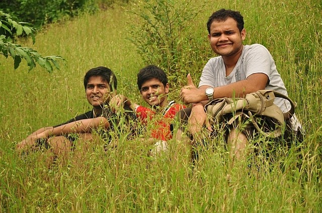
Tarun and Kunal with Kohoj in Background
Reaching Vaghote (वाघोते):

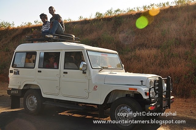
Kohoj fort lies off the Manor-Wada highway, one of the road joining NH8. So reaching Vaghote was very much similar to reaching the village at the base of Asherigad. After reaching Palghar, we boarded Nashik-Nandurbar bound state transport bus going via Manor-Wada highway. Only difference is that, a left turn from Mastan Naka on NH8 will go to Asherigad and a right turn to Kohoj.

Travelling in the state transport bus (लाल डब्बा ) for the first time, Kunal felt uneasy at first. But later enjoyed the ride when the driver picked up the speed. Kohoj fort was visible from the bus once it entered the Manor-Wada highway. Kunal's first reaction was- वहा उपर तक जाना है ? We had a hearty laugh.

From Vaghote (वाघोते) to Top: 

Breakfast at Palghar station turned out to be a perfect move from our side as finding any shops at Vaghote was beyond the realm of possibility. Without wasting a single minute, having set the proper direction on the compass, we set off. The first lake was very much close to the highway. It looked like it was dug out of stone, and the water in it was pretty clean. The byway goes straight to Shelte village. To reach the Pazaar lake, the branch going to the right side needs to be followed till the wall of Pazaar lake is seen.

Walk on the wall of the lake was highly exhilarating; the view of the fort, and the lake in its courtyard was appealing. Now, where the wall ends, trail enters the forest, and starts climbing gradually. By the time we reached the first open space on the slope, we were kinda lost. The route looked shaky and unclear. But we kept on following that route, with a vague feeling about this route meeting the main route. It did meet the main route. But before that we had to cross the thorny bushes, heaps of dried leaves, slippery rocks and what not. But with all this, Kunal didn't even showed a single symptom of the usual first time trek. Abhash and Tarun were also helping him restore his confidence at times. Aaditya and Manoj were helping me find the route. They also helped me to find a Conker-berry bush aka Bush Plum or Carissa Caranda or करवंद tree nearby. After feasting on the juicy fruits, we proceeded to the ridge where Kohoj hill actually starts. We had to climb the dried-up water stream to reach the col (खिंड). The strong winds welcomed us. Also, we found that the correct route was just beside the route we were climbing.


Trail after the col was straightforward and the possibility of losing it was null. The forest covered the full route and the dulcet tones of different birds filled the atmosphere. We could locate the remains of the main entrance to the fort. The approach to the top has a few standing remains of the fortification (तटबंदी). The top of the fort is a large plateau having a stone carving, Shiva temple, countable water cisterns, vestige of a standing structure, a naturally formed human-like structure, temple of Lord Hanuman, another stone carving of Lord Hanuman and Temple of Lord Krishna. It was surprising to see a Krishna temple, as it is very rare to see one dedicated to Krishna. One similar temple (newly built) was spotted on Mangi-Tungi ridge.

Lunch:

We had our lunch behind the Shiva temple. Aloo, chana masala were the favourites, khichidi, thepla, puri, pickles were other supporting goodies.


Exploring the Kohoj fort and getting down:


Naturally formed- human like structure


Abhash Kumar enjoying the nature

Manoj and his favorite pose


Kunal-Abhash-Tarun

Pazaar Lake (पाझर तलाव) aka Shelte Lake (शेलटे तलाव):


Pazaar lake

Kids enjoying a swim in Pazaar lake

Kids enjoying swim in Pazaar lake :)

This is a huge man-made water body which provides water to the Shelte Village and adjoining villages. Water from this lake is mostly used by people for washing purposes, bathing and by cattle. At ~4.30 PM, when we reached the lake, we decided to take a plunge into the lake and cool down the body. Before entering the lake, we first ensured that it would be safe for us there, confirmed with a herder (गुराखी) and then set forward to step our foot inside. It was also the usual bath time for the local school kids, and they were too enjoying themselves. An under water route follows upto the middle of the lake. The 30 minutes spent in the lake were assuaging. All the fatigue caused by the days trek had died out and had left us with enough sense of ebullience to finish the remaining trek. We were so very much charged up that we ended up in a wrong village instead of reaching the Manor-Wada highway!

Reaching home:

A tum-tum dropped us at Mastan Naka (मस्तान नाका) and charged us reasonably. A benevolent tempo-driver also gave us a lift till Palghar railway station. We reached just in time to catch the 7:30 PM, CST bound fast local train.

Now it was time for the Kohoj trek to enter the dossier on trekking.


Some more information:
Height of Kohoj fort is roughly 3200ft. The village at the base of Kohoj fort, Vaghote, can be reached from both, Thane as well as Palghar. Always consult a villager before taking a swim in the lakes, especially during rainy season (we always do). 

Trek to Kalavantin (कलावंतीण दुर्ग)

Difficulty Rating: Easy to Medium grade
A kind of difficult, but frequently visited by trekkers.
Height: ~2000 ft.
Cost: 98 Rs (INR) Including healthy Lunch, and transport from Dadar-Dadar


The plan was to meet at 7:30 AM at Panvel (पनवेल) station and catch a ST bus to Thakurwadi village from Panvel ST stand. But we reached a few minutes late and had to catch a bus going to Dadar via Shedung phata (शेडुंग फाटा). From Shedung phata we got into an auto (6 passengers in a 3 seater auto) and headed to the base village. We were a group of 6 (Abhash, Aaditya, Manoj, Tarun Gangwani and Deven). It was Deven's first trek and had no clue what all things to bring. So a day earlier, Tarun had asked Deven to bring heavy lunch, 2 steel plates, knife, bread, onion, tomato and all secondary stuff. Not to mention additional 2 Ltr water bottle !! 

The start:
A long and twisting route till the Prabal plateau aka machi in marathi (प्रबळ माची), gradually climbing with each step formed the beginning of the trek. On the way, we came across an open temple of lord Ganesh (गणेश) and Hanuman (हनुमान). The forts of Chanderi, Mahismaal could be spotted far far away. Started at 9:45 AM roughly from the base, we reached the Prabal machi at 11 AM. 

Prabal machi (प्रबळ माची):
There is a small dhaba (ढाबा) run by a local villagers. The village located at Prabal machi goes by the name Chikhale (चिखले). We spent about 20 minutes at the dhaba. Deven and TSEC Tarun were busy with their own photoshoot near an empty hut while Manoj was busy with his 'pet love' (Checkout the snaps with Manoj holding a cat). In the village, there were roughly 10-15 houses there, and a few villagers were busy with some construction work. The locals were eager to help us out with finding the proper route of the trek (which is behind the left-most house).


Climb to the col
The forest was a bit thicker here and the route had scree at a few places. This trail involved climbing the 35-45 degree slope covered with loose rocks. Within 20 minutes we reached the col and had the first hand feel of the pinnacle of Kalavantin.

The final climb:
Well, it reminded us of our previous trek to Harihar fort. But the only difference was that Kalavantin had proper steps and comparatively broader route. But one cant neglect the fact that the first look is always threatening.

Slowly and steadily we marched towards the top. The route seemed pretty safe now with our cautious walking. Manoj, as usual, was the first one to get scared, and also the first one to climb the pinnacle. Within 15 minutes we reached the top, also the base for the final 15-20 ft. rock climb. The final rock patch had sufficient hand and foot holds to climb so we didn't require rope. I climbed first, Abhash followed, then Tarun, Manoj, Deven, Aaditya... One by one we all climbed the pinnacle and yeah, we were on top of Kalavantin!!

At the top:
The top is fascinating, with steep slopes from all the sides. there are 2 saffron flags and a few huge boulders. Prabalgad, the one along the adjacent ridge, looked very close by, but yet so far.. We could easily spot the starting point of the trek, Thakurwadi village a few Dam and farmhouses. We spent nearly 30 minutes at the top, taking pics with all possible pose. Here is the group photo:


The descend and a long halt at dhaba:
Everyone was now very much desperate for lunch. We didn't have a morsel of food since the morning and now our second target was to reach the dhaba and relish on the goodies we were carrying.


It was 1:30 PM when we started the descend and the Sun had started heating up the rocks. When we were half way through the rock-cut steps, we looked down and saw a long queue, a group of about 40 people, slowly marching towards the top (towards us). Well as mentioned earlier, route was narrower than Harihar fort route, but not as narrow as to allow simultaneous two-way traffic. That group was really a big one, most of them looked first-timers, with their organizers carrying rope for them. Well, our time was perfect and we got past them and reached the col to celebrate the moment. Oh yes, and I stumbled across a classmate from IITians PACE, Saud, who was also in that group.


Very close to the col is a small cave, approx. 4ft. x 4ft. and neatly carved inwards. People say that this was the secret route to Prabalgad fort, and a similar one can be seen at the top of Prabalgad too. TSEC Tarun decided to glance through the cave route, but the dust inside cave made it impossible for him to proceed any further than 1m inside. Then Aaditya joined him too-

The Lunch:
And walking past Chikhale village, we reached the dhaba, located on the outskirts of the village. Then started the lunch... 'The Lunch'. Parathe, Idli-chutny, Chapati Bhaji, Pulao, Rice, The unlimited  Rice plate (Aloo ki sabji, Matar sabzi, papad, daal-bhaat), banana's and all other supporting food items like tomato, onion, lemon etc. This whole process lasted for 20 minutes. Added another 10 minutes for resting and then started off again to the base in order to catch the 4.00 PM ST bus back to Panvel.

Some idher-udhar ki baatein:
We met a group of 10-15 near Prabal machi. They asked about what we do, our college etc. When we told them our college name, we both literally jumped!! Most of them were SAKEC alumni (2008 passout) and their friends. (We too are from SAKEC, Mumbai University!!! except TSEC Tarun & Deven). Throughout the trek we were close by. Most of the time we were helping each other during the climb and descend.

The End:
So, all in all, trek was completed at 4:05 PM at Thakurwadi village and we reached our home by 6:30 PM (Dadar-Parel) to 7:30 PM (Andheri-Versova) in the evening.

Just 98 Rs. for such an awesome Adventure !! My Communication Systems book by Wayne Tomasi costs 600 Rs. !!! 

Trek to Nageshwar and Vasota

Fort type: Forest Fort (वनदुर्ग)

Nageshwar (नागेश्वर) and Vasota (वासोटा) - Well, the need for trekking in the forest, visiting an old fort, an hour of a ferry ride and a strenuous climb, all are satisfied here. But all you need to do this is a permission from Koyna Wildlife Reserve (forest department). Yeah, thats because this whole thing spreads along the backwatrs of the most famous Koyna (कोयना) dam. Its actually a Tiger reserve (कोयना व्याघ्र प्रकल्प) but the Wild Boar (रान डुक्कर), Indian Bison (गवा) are a commonly found wild animals here. 

People usually take the following route (toll route):
Satara (सातारा) - Bamnoli (बामणोली) - Met Indavali (मेट इंदावली) - Vasota (वासोटा)

We first climbed Nageshwar, visited Vasota fort, then camped at a God-forsaken place the second day, deep inside forest, then made an unsuccessful attempt to reach a village on other side, then headed back on the fourth day. 

(The story of the successful attempt coming soon. It was during December 2014, exactly one year later. Link will be posted here as well)

Till then, enjoy a few pics and videos !!

From Vasota Fort
A short version of the trek to Vasota and Nageshwar, IN


Trek to Harihar हरिहर (Ghoti-Vaitarna, Igatpuri)

Difficulty Rating: 4/5
Height- 3676 ft.
Per head cost- 300 ₹ (Mumbai to Mumbai)
1 day- 1 night

The beginning: 
Our group consisted of 5 to-be Electronics Engineers and 2 full Engineers, so total group of 7. The destination being Igatpuri (इगतपुरी), we were equipped with sweater, blankets, monkey-cap, mufflers etc and were ready to spend the night at Igatpuri ST stand with the mercury level falling below 10 °COur train journey mainly consisted of making fun of our college professors, how our external examiner looked funnier than any existing cartoon, discussion on how 'awesome' our college facilities were.... and most of the time- एक दुसरेकी टांग खिचना.... The discussion on IMS management classes-marketing strategy lasted for quite some time !!

If your leader says the trek is tough, its not because the trek is tough, its because he/she is weak and has zero confidence in you. I had 2 newbies in my group and they appreciate my confidence in them :)

We reached Igatpuri station at 3:10 AM, and the moment we got down the from the train, we got the feel of the cold night we were about spend there. At the ST stand, Abhash and TSEC Tarun were off to sleep- डोक्यावर कानटोपी अन अंगावर चादर, अगदी गावठी style माध्ये !! Meanwhile Manoj and Aaditya found a small piece of half-burnt wood and brought it inside the bus stand, and made a शेकोटी out of it. To keep the fire burning, we used the posters of local politician as the fuel and at the same time, Aaditya made sure that each and every poster was removed from the wall !!

At around 4:30 AM, one by one, we all went to sleep and had a quick nap of an hour and a half. SAKEC Tarun didn't have any intentions of sleeping (ट्रेन मे बोहोत सोया था) so he was keeping a vigil- may be it suits his aspiration for joining Indian Army !!

Journey till Nirgudpada (निरगुडपाडा) aka Taakehars (टाकेहर्स): 

The first ST bus was scheduled at 8.45 AM (2013, timings might change). The next bus was at 2.00 PM.


The awesome village roads, full of twists and turns surrounding the Vaitarna lake would be definitely worth mentioning. The traditional rural cattle smell, the hay-stacks, small farms, bore-well was the common yet pleasant sight to look at rather than the everyday concrete buildings and busy roads  in the city. On the way we come across helluva Sahyadri mountains lying in the Igatpuri region, prominent being- Anjaneri, Trimbakeshwar, Bhasgad, Tringalwadi, Fani Dongar, Alang-Kulang-Madan far far away and Harihar of course.

The Trek: 
The ST bus reached Nirgudpada at 10:25 AM. We packed our sweaters-mufflers etc, tightened our shoe lace and started the trek at 10:30 AM.

If you arrive from Khodala or Igatpuri, Harihar would be on the left-hand side. Just where the bus stops, take any route going towards the fort. It is confusing to find the correct trail out of many complex-intermixing trails, but focus on the trails which climbs towards the plateau on the left side of the fort. From the plateau, the ridge takes you to the start of another gradient and later to the rock-cut steps. After that the route to the top was straightforward, but a bit exposed to valley. Take extra care while crossing this section. Here are a few snaps of overall journey.


The village ends here. Started climb for the first plateau

TSEC Tarun and SAKEC Tarun

Fani Dongar (फणी डोंगर) in the background

Harihar Fort (हरिहर किल्ला)
Climbing the first set of rock-cut steps
Crossed the main entrance (महा दरवाझा) at 11:38 AM
Hanuman Temple at top (हनुमान मंदिर) 
Reached the highest point of the fort at 12:05 PM
Lunch:
Aloo parathas (आलू पराठा), Theplas, Puri bhaji (पुरी भाजी), Shira (शीरा) consisted of our lunch. Our lunchboxes were empty within 15 minutes they were opened. It was worth noting how the items were gobbled- given the tough climbing conditions.

Descend: 
Reached the base at 3.10 PM. Clicked a lot of pics on the way. Here are some of them..

Second pair of rock-cut steps
Small rock patch
A walk to remember !!
Fun time
The video below shows a part of the descend.


Return Journey: 
In the evening there are two ST buses- ST to Kasara and ST to Igatpuri (both at approx. 3.30 PM ) from Nirgudpada. If not the bus, Jeeps usually ply on the Ghoti-Vaitarna road from Trimbak, and can drop you at khodala. At 3.20 PM we left Nirgudpada 'on' a Mahindra MaXX (yes, we were literally sitting on the carrier) which dropped us at khodala and from Khodala, another MaXX till Kasara railway station. One can also catch a ST bus from Khodala to Kasara, but since we didn't know the timing we preferred a jeep. The total passengers travelling on the jeep were 22 + 1 driver (front 3, 5 on middle seat, 3 hanging outside on the left side, 3 hanging outside on the back side and 8 people sitting on the back seat).

TSEC Tarun and SAKEC Tarun on the top of Mahindra MaXX 
Khodala to Kasara is 25 Kms. After some 17 Km ride, the small dirt road joined the Mumbai-Nashik Expressway- but on the wrong side of the road!! We were in a vehicle, which was driving on the right hand side of the busy  AH47, with other vehicles speeding towards us from the front. After the 2-3 Km of this circus we joined the 'our side of the road'. We reached Kasara station at 5.00 PM roughly and boarded the local train to Kalyan (which was the only option before us). From Kalyan, caught another local to Mumbai CST and by 10.15 - 10.20 PM everyone was at home.

Here's the link to the Marathi version written by Aaditya Gurav. Its a book in pdf format. Click here to download the book.

Please note: We had 2 newbies in our group and we all made it to the top. It depends on their spirit, confidence of leader and their trust in you. Its not possible with commercial big groups, and they will frighten you to not join as they don´t want to take any risk, but maximize profit. Trekking is fun guys, especially when history is involved in it :)

Our Group:
Abhash kumar, Manoj Patil, Ninad Vilankar, Aaditya Gurav, Tarun (Gangwani & Kaushik) and me.

Short adventure near Peb fort

This is a short cut route. 
Height- 2000 ft.
Per head cost- 140 ₹


The view of Matheran (माथेरान), Peb (पेब ) fort, Nakhind (नाखिंड), Chanderi (चंदेरी), Neral (नेरळ) and Panvel (पनवेल) region as seen from the top of Mountain X.

The Overview:

The fine day of 11th October, 2013. Plans were being executed as scheduled (thanks to Anurag). We were clueless that the destiny had so much laid down before us that day. It made us lose our way in the forest, forced us to climb the dried-up waterfall route, compelled us to climb a 100ft. 75-80 degrees of rocky patch- and for what? to find ourselves onto a completely different top, which we named "Mountain-X". It was 2.30 PM, and we were at the top of 'X'. The route to Peb was now crystal clear before us. But the time constrained us to follow the return path.

Anurag, Maitreya, Saurabh
The correct route to Peb (Better you ask for directions @ base and then proceed):

1. Neral > Fanaswadi > Peb
Ask a villager at Fanaswadi about the directions. A bit complex route. More chances of getting lost if visiting for first time. Villagers might help out here. Make the decision of taking a guide here itself. Because, if you are lost out there, theres nobody to help you out.

2. Neral > Electric Tower route > Peb
Clear route. Risky at some places, but manageable. It follows via thick forest and 'X'. Only concern is forest. Stick to the route and it'll take you to the top. After reaching 'X' descend into the gully between Peb and 'X'. Follow the visible route to Peb. The diversion to the right, big enough to spot, leads towards Panvel. Overall longest route and lesser chance of getting lost.

3. Neral > Waterfall route > Peb
Will write about it once we try it out.

Maitreya
The silver lining:

Though we lost our way, we successfully climbed the rock patch. Not only that, but made Saurabh climb the route too. It was tough, but "we finally did it'.


We had the climbing gear but didn't use anything of it. The team consisted of four of us- Anurag Muley, Maitreya, Saurabh Shah

Trek to Manikgad Fort, Washivali (Complete Guide)

Region: Rasayani, Panvel
Height- 1876 ft.
Per head cost- 108 ₹
Water is available at top during Monsoon


It was the dawn of 13th July, 2013. As planned Abhash, Ninad, Atul met me at Dadar station at 6.15 AM. Bhavesh, Suresh and Manoj were supposed to board the local train from Mankhurd station. Tarun called us to inform that he will be joining us at Nerul station. Everything went as per our timetable and all were in the same train. We reached Panvel (पनवेल) station at 7.30 AM after having boarded the 6.35 AM local from Kurla station.

Note: Before you start, check out my latest visit to Manikgad too. It has lot of info which I couldn't cover here. Click here.


The start:

We walked to Panvel ST bus stop, which falls at a distance of 10/15 minutes. The trek to Manikgad (माणिकगड) fort begins form Washivali (वाशिवली) village. We boarded the 7.45 AM ST bus to Lohop village (लोहोप), a village after Washivali. The bus was crowded but still we managed to find ourselves some seats. The bus left as per the scheduled time. The charges till Washivali were 20 ₹ per head. When we were outside the Panvel city the bus broke down, unable to start again. Luckily there was another ST bus behind us, but sadly it was going to some different village. It dropped us at a junction named Siddheshvar (सिद्धेश्वर), from which Washivali village falls at a distance of 20 minutes. From there we boarded an Auto that took us to Washivali village for 10 ₹ per seat.

The Route :

From Washivali, two routes originate from the main road. The first right proceeds via Katarwadi (कातरवाडी). The second right goes via Dhangarwadi (धनगरवाडी). Then both routes meet ahead after about an hour. We took the second route.

We started towards Vadgaon (वडगाव) village. We came across a big temple (to our right hand side), and we took a right turn there and entered a village (from behind the temple) and proceed to Dhangarwadi. This route has a full green cover throughout, till the route from katarwadi meets this one. So we started walking at 9.00 AM from Washivali village and reached Dhangarwadi at 10.15 AM. Dhangarwadi lies a few steps away from main route to Manikgad Fort. This is the last shelter and there are no houses nor huts after this point.

Tip: No need to go all the way to Vadgaon village. This saved a lot of our time. People with cars usually go till Vadgaon village. We travel by state transport, and if you are also planning to visit by a state transport or similar, then I would recommend you to start your hike from Washivali village. Its easy, safe and you will meet people on the way. Just ask for way to Killa (fort) and the villager will point out to you.

The long traverse:


The next level of the trek was the long & tiring traverse till the Hanuman temple. The route till this location was a straight forward, but the places near waterfall had completely gobbled-up the route and hence left us on a wild goose chase. Every time we encountered a small waterfall, the route following it had disappeared, eaten up by huge boulders. So, many times we found ourselves lost amidst thick forest, with no route visible ahead of us but only thorny bushes and irksome mosquitoes. But thanks to our team work, we were able to bring the horses back on the track.

Somehow we managed to reach the Hanuman temple and started walking straight ahead. And this is where we made our first mistake, the mistake of the day, which costed us our precious 45 minutes.


Getting lost in the forest:


We were carrying this (stupid) map and were navigating the route exactly as it was drawn there. Now, what map said was to continue traversing after the Hanuman temple and then after about 20 minutes the climb starts (this is what map told us). So we did, and walked and walked and walked. We knew we were lost. Because there was no route at all. It seems we were making our own route. We were so very much lost, that we could easily make out that we were heading to Mashyachi Khind (माश्याची खिंड), the col between the Manikgad valley, while the route to the top should be heading to our left.

The miasma of despair:

We were walking continuously for 3 hours straight, without even resting for a bit. We got lost in the forest, took a wrong turn to get diverted from our path, spent some of our precious time to get on the correct route and what not. We decided to reach the Hanuman (हनुमान) temple for analyzing our further course of actions. No one was able to think clearly. Suresh was the first amongst us to panic, he had enough of all this and wanted to start the descent right away. It was a frustrating as well as disappointing moment for all eight of us. Disappointing, because we had trekked for three hours, continuously, without resting. Frustrating, because the fort was still envelope by thick fog and was still not visible. What was the point of walking ahead if the goal is not in sight ahead? I mean, how could this happen? We were following the map exactly as it was. We had came this far and so, we were determined to reach the top. But how? Ninad and Bhavesh were busy contemplating on the possible errors we might have committed; Tarun, Abhash, Manoj and Atul were enjoying the merry mellifluous sound of the water stream, while Suresh were resting, too frustrated to think of anything. The Miasma of despair had started rising. I was afraid of the worst, what if we can't find our way to the top?

Ready to roll again !!!


And just when we were about to forfeit our plans to ascend the fort, two dogs came hopping out of nowhere with their masters following them. And pointing towards them, Tarun gave a sudden jolt of joy and shouted, "lets ask them". They were the local villagers from Katarwadi, who had come hunting in the forest. We approached the one in the front and explained our situation to him.

We persuaded a villagers to show us the way and he gave us a positive nod. Now we were on our feet, ready to roll again. Now Suresh, Atul and Manoj too geared up, thanks to some gentle coaxing from Abhash. It was 12.00 PM then. After walking for about a minute, we came to the spot where the route manifolds into three different paths (earlier, from where we had taken the one to the right, only to find ourselves amidst thick forest, having lost our way). The villager told us that the correct route was to take a left turn, instead of right. He took us till the turn and ask to follow that route. We were on the correct track again and highly delighted at the same time. 


Stupid Map!!!

The trek to the top was a gradual climb, but comparatively easy and was accomplished in 40 minutes (again, without resting). The bliss experienced by the adjacent valley, Mashyachi khind was indeed a moment to savor. The route followed under the thick cover of the forest, all the way to the top of the fort.

The Fort:

Well, the fort was not actually a fort, it was more like a vestige of a few standing structures. The first door to the fort (महा दरवाझा) was completely destroyed. The second door, was atleast, looking like a door, and had a sculpture of lord Ganesha (गणेश) inscribed on it. There are more than four water tanks, two on the way, and the rest on the top, with the one tank resembling the size of a huge swimming pool. There was a small temple on the top, unfortunately, with no deity inside. The God/Goddess idol was probably stolen by invaders. Beside the temple, there was a (चुन्याचा घाणा). We spent like 45 minutes on the top. We had our lunch while enjoying the fog. The clouds had completely blocked the visibility, so we were unable to enjoy the valley, but we enjoyed the thrill of having our lunch on the very edge of the fort.


The Descend:

Now that we had accomplished our purpose of coming here, we had all the time in the world to start the descend. After the prolonged photo session, we started the climb down at 2.00 PM. When we were midway near the Mashyachi Khind col, the sky had started clearing, exposing the magnificent view of the valley. We even came across two odd groups, probably amateurs, accompanied by a guide from nearby village, while we were navigating the forest patch. They looked enervated and had gloomy faces. They must have had a tough time walking the stretch of 12 Kms. But we were happy we successfully climbed the fort without any guide or something.


Now we were heading for a mini-waterfall which we had encountered on our way earlier. We spent complete 30 minutes, 3.15 PM to 3.45 PM, enjoying the moment to the fullest. The rain was, as usual, making his intermittent display throughout the trek, which kept us lively at every moment. As we approached the village, we made slight changes in the plan, and decided to progress via Katarwadi village, instead of the route via Dhangarwadi. The route was a bit untidy as it went through the village, but somewhat similar to the earlier route we took.


We reached Washivali village at 5.30 PM. We were waiting for the ST bus to arrive, when Atul, Manoj, Suresh were searching for a secondary mode of transport. A TATA Magic guy promised us to drop at Panvel station for 40 ₹ per head. We reached Panvel station, right on time to catch the ~6.30 PM local train.

For newbies, I would recommend you take a guide with you (don't rely on any map). This was my second time here and I have almost learnt the route by-heart now.

Thanks to Atul Mallya (and his HTC Phone camera), we were able to preserve the Manikgad adventure in the form of photographs. All these snaps were captured from his camera.


Update: Click here to read my November 2014 visit to Manikgad.

Our most recent adventure...

Chanderi fort trekking

Date: January 2021 Trek type: Jungle fortress, 714 m Difficulty: Walking on moderate to difficult terrain (no rock-climbing) Availability of...